
Page 457 - tmp
P. 457
I find it hard to understand with reason, with reference to why police officer(s) would be sent to a location that
the person was not at, as it seems PC Steve Elsmore is trying to imply in his statement dated the 24/09/2016
pages 327 to 332.
Also, there is the matter regarding data blocked out in a multitude of CFS Emergency calls relating to: -
1. CAD 3151
2. 2410 to list a few more, I can understand some Names and some Addresses but clearly not what I
request as disclosure so that I can read what is needed to stand a fair defence, there is clearly a lot
more data being blocked out that is vital to the on goings of this case.
There is a problem with Cads missing like linked CAD 2456 /7 shown on many pages as shown on page 290.
The reason given by the respondent in court about explicitly linked to and implicitly linked to CADs seems very
unreliable, and could easy be proved by showing the judge these missing CADs are not linked in any way.
In statement of PC Jason Ames dated the 15/08/2014 it states CAD 9717 which related to intelligence, why has
this been withheld also?
Using the jurisdictional GIS information and the law enforcement map layers, the dispatcher has a tactical view
of the city and/or dispatch area. The map can be controlled by specific CAD commands, such as zoom-and-pan,
or preset commands, such as zooming to the address of a selected call for service.
The dispatcher can map/view all units and open calls for service for an area or the city. Units and calls are
labelled on the map.
Locational Systems Interfaces Locational systems provide automated access to address, geographic, and
mapping information for law enforcements. The primary locational systems include AVL, GIS, and Mobile and
Real-Time Mapping:
Geofile Maintenance: -
The creation of a comprehensive Geofile is a significant undertaking. The system should support the creation and
maintenance of the Geofile using an available mapping/GIS
The Geofile contains the geographic information that is the basis for many decisions in a communications centre.
The system needs to provide the ability for an agency to enter and update all Geofile data, including the physical
address and the X/Y/Z coordinates.
The Geofile is used to validate and standardize location and address information. It is also used to cross-
reference addresses and locations with law enforcement-defined reporting areas, X/Y/Z coordinates, ZIP codes,
and other identifiers. The Geofile contains sufficient information to ensure that an address is valid. Furthermore,
it provides cross-references to addresses and locations using common place names (e.g., business names, parks,
hospitals, and schools) and street aliases.
It includes information such as direction of travel on particular streets and can identify the side of a street for a
specific address. It is assumed that all addresses in the RMS are validated using the system Geofile.
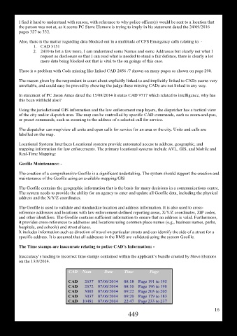
The Time stamps are inaccurate relating to police CAD’s Information: -
Inaccuracy’s leading to incorrect time stamps contained within the applicant’s bundle created by Steve Elsmore
on the 13/8/2014.
CAD Num Date Time Page
CAD 2637 07/06/2014 08:18 Page 191 to 195
CAD 2672 07/06/2014 08:16 Page 196 to 198
CAD 3005 07/06/2014 09:22 Page 203 to 205
CAD 3037 07/06/2014 09:20 Page 179 to 183
CAD 10481 07/06/2014 22:47 Page 233 to 237
16
449